| Author |
 Topic Search Topic Search  Topic Options Topic Options
|
Gay3 
Moderator Group

Joined: 19 Feb 2007
Location: Miners Rest
Status: Offline
Points: 52011
|
 Post Options Post Options
") Thanks(0) Thanks(0)
 Quote Quote  Reply Reply
 Posted: 21 Jul 2015 at 1:12pm Posted: 21 Jul 2015 at 1:12pm |
Due to maintenance upgrades Powercorp had a need to kill our power supply from 9 'till 3 today which hasn't affected our use of TV, computer of hot water jug but our aircon's directly wired thru' the wall to the power box, I suppose. We now have an outside feels like of 6C & it sure doesn't feel much warmer in here  . Geez I hope they get done early 
|
|
Wisdom has been chasing me but I've always outrun it!
|
 |
James Bond Esq
Champion
Joined: 20 Sep 2013
Location: Melbourne
Status: Offline
Points: 13905
|
Post Options
Thanks(0)
Quote Reply
Posted: 21 Jul 2015 at 5:44pm |
|
Did they get done Gay?
|
|
Gay3
Moderator Group
Joined: 19 Feb 2007
Location: Miners Rest
Status: Offline
Points: 52011
|
Post Options
Thanks(0)
Quote Reply
Posted: 18 Nov 2015 at 5:15pm |
CFA Updates
@CFA_Updates
2hrs ago
Smoke haze in Victoria due to fires in Western Australia. Thoughts go out to colleagues & community in WA #wafires

|
|
Wisdom has been chasing me but I've always outrun it!
|
|
Dizzy
Premium

Joined: 17 Sep 2013
Location: Canberra
Status: Offline
Points: 16863
|
Post Options
Thanks(0)
Quote Reply
Posted: 18 Nov 2015 at 5:17pm |
|
It's not good In WA at all, four already reported dead in the Esperance fires.
|
|
Gay3
Moderator Group
Joined: 19 Feb 2007
Location: Miners Rest
Status: Offline
Points: 52011
|
Post Options
Thanks(0)
Quote Reply
Posted: 18 Nov 2015 at 5:44pm |
Figured there must've been, Turnbull offering condolences came up on my feed earlier, poor devils, those left behind I mean 
|
|
Wisdom has been chasing me but I've always outrun it!
|
|
horlicks
Champion
Joined: 26 Feb 2010
Status: Offline
Points: 8416
|
Post Options
Thanks(0)
Quote Reply
Posted: 18 Nov 2015 at 6:14pm |
|
Apparently 3 were German backpackers, and the other a local farmer
|
|
Gay3
Moderator Group
Joined: 19 Feb 2007
Location: Miners Rest
Status: Offline
Points: 52011
|
Post Options
Thanks(0)
Quote Reply
Posted: 17 Mar 2016 at 7:25pm |
|
Presently 25.8C down to 11C by 9a.m. & plenty of rain forecast, luckily Kyneton have sensibly withheld irrigationto 4mm last 24 hours, 14mm last 7 days.
|
|
Wisdom has been chasing me but I've always outrun it!
|
|
Go Flash Go
Champion
Joined: 08 Mar 2007
Location: Victoria
Status: Offline
Points: 10250
|
Post Options
Thanks(0)
Quote Reply
Posted: 18 Mar 2016 at 9:40am |
Over this summer every time it's started to dry out we've got rain just in time to green things up and ward off the fire danger.
Could say it looks pretty safe now for this year with this current lot of rain, was difficult to before.
|
|
Gay3
Moderator Group
Joined: 19 Feb 2007
Location: Miners Rest
Status: Offline
Points: 52011
|
Post Options
Thanks(0)
Quote Reply
Posted: 18 Mar 2016 at 9:52am |
In your neck of the woods perhaps, Flash
|
|
Wisdom has been chasing me but I've always outrun it!
|
|
Go Flash Go
Champion
Joined: 08 Mar 2007
Location: Victoria
Status: Offline
Points: 10250
|
Post Options
Thanks(0)
Quote Reply
Posted: 03 Apr 2016 at 3:43pm |
South of the divide .... yes .... drying out a little now 
|
|
Go Flash Go
Champion
Joined: 08 Mar 2007
Location: Victoria
Status: Offline
Points: 10250
|
Post Options
Thanks(0)
Quote Reply
Posted: 06 Apr 2016 at 10:01am |
.... and so here's that rain 
|
|
Gay3
Moderator Group
Joined: 19 Feb 2007
Location: Miners Rest
Status: Offline
Points: 52011
|
Post Options
Thanks(0)
Quote Reply
Posted: 14 Apr 2016 at 6:45pm |
Seasonal Outlook for South West Victoria, issued April 15, 2016
Summary :
Generally, the outlook for Victoria is for an average to above
average 5 month in regards to rainfall. Temperatures are likely to be
milder than normal for the whole state, owing to the warm Sea Surface
Temperatures injecting additional moisture over the country. A lot of
what occurs will depend on the Indian Ocean, and its ability to stay
warmer than normal through the winter months. If we see a Negative
Indian Ocean Dipole this could set the stage for well above average
rainfall for most of the country, particularly South Eastern Australia.
This will be refined over the next 8 weeks, as the IOD is important to
winter patterns across the country. Victoria also benefits from being
close the coast, where frontal activity can enhance rainfall. However,
winter fronts may well be suppressed due to high pressure placing at
lower latitudes.

Decile Scale
1 – 3 Below Normal
4 – 7 Near Normal
8 – 10 Well above normal
The forecast is in blue, the red is the forecast i have made last
month so you can view the changes I have made. This will be an ongoing
thing as then you can see which way the bias is heading. Both May and
June are slightly above normal, June is the target month and the
wettest. July and August should be somewhere about normal, and then a
wetter trend should develop in the Spring. The target months are the
next two, with confidence high, and then medium confidence for the last 3
months.
Notes : With the decile scale, a decile 6 would imply
slightly to the wetter side of average, and 4 would imply a slightly
drier bias to the forecast.
Disclaimer : This forecast is
the intellectual property of A.V. Weather, and isn’t to be redistributed
online without my written consent. This is a long range forecast and is
to be used as a guide only only, A.V. Weather will under no
circumstances be held responsible for any loss incurred from this
outlook, which has lower forecast accuracy than a normal forecast. If
you any issues, please use this form to contact me. http://www.avweather.net/contact-us/
|
|
Wisdom has been chasing me but I've always outrun it!
|
|
Gay3
Moderator Group
Joined: 19 Feb 2007
Location: Miners Rest
Status: Offline
Points: 52011
|
Post Options
Thanks(0)
Quote Reply
Posted: 27 Apr 2016 at 8:21pm |
Outlook for Warrnambool  From A.V. Weather
Week 1, April 27th – May 4th.
Cold fronts are going to begin to affect the Victorian region this week.
The first front on Thursday will weaken as it runs into high pressure.
Another stronger cold front will be approaching from the west on Friday.
Widespread colder conditions are likely over the weekend into Next week.
On Tuesday, another front will be approaching from the west.
Rainfall : 15 – 30 mm, possible heavier falls to 50 mm in the SW coastal regions
Forecast Confidence : High
|
|
Wisdom has been chasing me but I've always outrun it!
|
|
Go Flash Go
Champion
Joined: 08 Mar 2007
Location: Victoria
Status: Offline
Points: 10250
|
Post Options
Thanks(0)
Quote Reply
Posted: 03 May 2016 at 11:17am |
The wind is very windy today Tuesday -
- like wild weather but am vey happy to be inside doing bookwork this time  |
|
Magnolian Khan
Champion

Joined: 23 Dec 2015
Location: SA
Status: Offline
Points: 8437
|
Post Options
Thanks(1)
Quote Reply
Posted: 03 May 2016 at 11:33am |
|
I'm just back from the US, so am snuggled up in bed watching the races readjusting to Australian time. Hopefully we get a bucketload of run, our farm really needs it
|
|
Magnolian Khan
Champion
Joined: 23 Dec 2015
Location: SA
Status: Offline
Points: 8437
|
Post Options
Thanks(1)
Quote Reply
Posted: 03 May 2016 at 11:33am |
|
Bucketload of RAIN
|
|
Gay3
Moderator Group
Joined: 19 Feb 2007
Location: Miners Rest
Status: Offline
Points: 52011
|
Post Options
Thanks(0)
Quote Reply
Posted: 04 May 2016 at 10:34am |
Weekly Central Vic Forecast
Weekly Update, issued May 4th.
Weather Situation :
A strong upper trough is now
moving away from Victoria and sliding into the Tasman Sea. During this
week, and in feed of moisture will move into WA from the NW and begin
feeding SE. At the same time, a strong cold pool is going to move up
from the South of Perth and cut off into a low. This will move East On
Friday and begin to drag in the upper trough that will slide in ahead of
it. Somewhere over the interior of WA and SA region, a rain band will
develop and intensify as it moves across the country, and feeds into the
low in the Bight. This will set the stage for a very large scale event
that has the potential to bring severe weather, with gales and locally
heavy rainfall. it will impact South Australia on Saturday afternoon and
by Sunday morning will be affecting Western Victoria. By Sunday night
it is likely that it will into NSW, and in its wake widespread rain will
occur. B Monday the Northern areas of NSW and Southern and Central QLD
will also see widespread rain develop, locally heavy.
———————————————————————————————————————————————————————-
Week 1, May 4th – May 11th.
Fine weather for most of this week as a succession of fronts exits the region.
On Friday, a large scale system develops over WA and begins to move East.
By Sunday the system will reach Victoria, where widespread rain and thunderstorms will develop over the region.
The heaviest falls will be through Central and Eastern parts, and into the NE of the state.
The secondary component of the low wrapping around will happen on
Monday night into Tuesday, and widespread rain is also likely across the
state again.
Rainfall : 20 – 40 mm. Possible falls to 60 mm near the ranges.
Forecast Confidence : High
———————————————————————————————————————————————————————–
Week 2, May 12th– May 19th.
A secondary burst with the wrap around low moves East on Wednesday,
the showers will begin to ease on the first two days of this period.
A small fine spell is likely to develop during this week, before another trough develops from the west late in the period.
A this stage the trough is likely to affect Victoria but will be weak.
Cooler conditions are likely for the remainder of the period.
Rainfall : 10 – 20 mm, mostly early in the period.
Forecast Confidence : Medium / High
|
|
Wisdom has been chasing me but I've always outrun it!
|
|
Gay3
Moderator Group
Joined: 19 Feb 2007
Location: Miners Rest
Status: Offline
Points: 52011
|
Post Options
Thanks(0)
Quote Reply
Posted: 15 May 2016 at 9:31am |
Weekly Update, issued May 14th.
Weather Situation :
A stable pattern has set up
over the interior of the country, with a large high pressure system
currently stationary. Over the next 7 days weak cold fronts clip the
South of the country, before a stronger front moves through the Lower SE
SA, Victoria, Tasmania and Southern NSW on Thursday. Then an upper
trough develops over WA, and amplifies as it crosses Southern Australia.
At this stage it looks like it will interact with a surface trough over
the NT, and interact next week weekend.
Week 1, May 14th – May 21st.
A large high pressure system is ensuring stable weather over most of the country this week.
On Thursday another front impacts Victoria, falls will be generally be between 1 – 4 mm.
Conditions will again become fine, although cloud begins to increase on the weekend as the next system approaches
Barring this conditions will be dry with sunny and mild weather expected for the remainder of the period.
Rainfall : 5 – 10 mm.
Forecast Confidence : Very High
———————————————————————————————————————————————————————–
Week 2, May 22nd– May 29th.
A large upper trough will move into West Australia next Sunday.
This will become the dominant weather feature this week, with widespread rain likely.
An upper low is likely to from on this Long Wave trough and spread rain right into the interior of the country.
A low pressure system develops as it nears Victoria, and may interact with a surface trough moving South from the Top End.
At this stage widespread rain is likely, mostly in the inland areas in the middle of the period.
Rainfall : 15 – 25 mm.
Forecast Confidence : High
|
|
Wisdom has been chasing me but I've always outrun it!
|
|
Go Flash Go
Champion
Joined: 08 Mar 2007
Location: Victoria
Status: Offline
Points: 10250
|
Post Options
Thanks(0)
Quote Reply
Posted: 27 May 2016 at 8:35pm |
|
Pretty close we got the rain (and the cold)
|
|
Gay3
Moderator Group
Joined: 19 Feb 2007
Location: Miners Rest
Status: Offline
Points: 52011
|
Post Options
Thanks(0)
Quote Reply
Posted: 16 Jun 2016 at 12:48pm |
Weekly Central Vic Forecast
Weekly Update, issued June 15th
Weather Situation :
A strong upper level low is
currently producing showers over WA, and will spread into South
Australia over the next two days. An upper trough will develop on
Thursday and move North towards Central Australia, and drag in some
moisture from the NW. This will interact to develop a very large scale
system, that will begin in Central QLD and then drive South into NSW
over the weekend. Widespread rain and thunderstorms will become
widespread and slide down the East coast, and enter Victoria early next
week. It will then clear Eastwards on Monday and Tuesday after it cuts
off into a strong Low pressure system. Another big system will develop
on Monday in SW WA as well, and this will bring widespread rain South of
Geraldton, and this spreads into South Australia on Tuesday.
Week 1, June 15th – June 22th.
Conditions will be fine to start this period, with an onshore flow.
A strong upper low and trough moves through on Thursday into Friday, producing showers.
On the weekend this moves into NSW, and then a big surface low forms in NSW and moves back towards Victoria.
Over the weekend, and on Monday, rain enters the Eastern half of Victoria as the low moves down towards the NSW South Coast.
Widespread heavy rain is likely to wrap around into Southern and Eastern Victoria.
Rainfall : 15 – 25 mm.
Forecast Confidence : High
———————————————————————————————————————————————————————–
Week 2, June 23rd– June 30th.
A strong low pressure system exits the state on Tuesday and moves out into the Tasman Sea.
Around the middle of the week another cold front and associated low pressure trough moves into Victoria from the west.
Another burst of showers will move across the state in a fast moving
pattern, and further fronts continue to stream in from the West.
Very late in the period, a very large scale Long Wave Trough will develop in WA and move across the Country.
Rainfall : 15 – 25 mm.
Forecast Confidence : High
———————————————————————————————————————————————————————-
Week 3, July 1st – July 8th
An upper trough will now start to develop over the country and bring widespread rain into country.
This is likely to become the focus for the following two weeks.
Widespread rain will move across the country again from the NW, spreading inland and producing widespread rain.
The heaviest falls are likely in every state except WA, where a ridge
should keep most of WA dry, except for the South West and coasts.
Rainfall : 25 – 40 mm
Forecast Confidence : High
———————————————————————————————————————————————————————
Week 4, July 9th– July 16th
Further low pressure is likely during this period, with the barrage of cold air to continue to pound the Southern areas.
Further rain events are likely as this interacts with further tropical moisture from the NW.
Southern areas will do best during this period as an upper ridge over the interior may temporarily dry things a little.
Rainfall : 20 – 30 mm
Forecast Confidence : Medium
———————————————————————————————————————————————————————
Notes : Obviously
the first two weeks are the targets weeks, what happens with these two
weeks will determine the following two weeks downstream of that.
We are moving into a very
active period with a lot of things going on, and the weather will change
quickly. Hence, I will be updating these pages regularly to give
subscribers the best information as it occurs.
|
|
Wisdom has been chasing me but I've always outrun it!
|
|
Gay3
Moderator Group
Joined: 19 Feb 2007
Location: Miners Rest
Status: Offline
Points: 52011
|
Post Options
Thanks(0)
Quote Reply
Posted: 16 Jun 2016 at 1:00pm |
Very different expectations for the next few months between Elders & A V Weather. 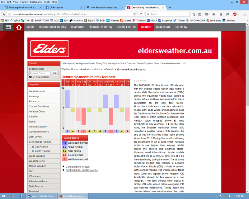

The forecast is in blue, the red is the forecast made last month.
"I think we are going to see a biblical Spring, and as we get closer I
will try to narrow down the areas because I think the whole country is
going to cop it.
And yet, still other organisations are talking dry, which is very
humorous! If you haven’t seen the shift by now you must be seriously
delusional."
Edited by Gay3 - 16 Jun 2016 at 6:39pm
|
|
Wisdom has been chasing me but I've always outrun it!
|
|
Gay3
Moderator Group
Joined: 19 Feb 2007
Location: Miners Rest
Status: Offline
Points: 52011
|
Post Options
Thanks(0)
Quote Reply
Posted: 18 Jun 2016 at 8:26am |
I hope the power companies have plenty of energy to cope with our heating needs as it looks like our turn towards the end of next week. I for one will be sooking regardless  And then the big one.

This system is going to be just epic, especially if these progs are
correct. This is an extraordinary burst of cold air, likely to bring
severe weather and low level snow to Victoria, NSW, and parts of SA.
We wont even talk about Tasmania, they will have so much snow it may look like New York in a blizzard.
Have a look at these 500 mb temperatures.

The temperatures that will over Victoria are the same as the temps
down in Antarctica, this should give you an indication as to what sort
of weather we are going to see next weekend.
It is simply going to be brutal, and this model is completely under
doing the rainfall and carnage that is going to come with this, it will
snow its balls off right up into the Tablelands and beyond IMO.
And gales, and freezing conditions behind it, so we will see
widespread frost as well from here on, any clear nights will be dropping
into the negatives quickly.
|
|
Wisdom has been chasing me but I've always outrun it!
|
|
Go Flash Go
Champion
Joined: 08 Mar 2007
Location: Victoria
Status: Offline
Points: 10250
|
Post Options
Thanks(0)
Quote Reply
Posted: 19 Jun 2016 at 1:24pm |
"The temperatures that be will over Victoria are the same as the temps down in Antarctica "
Yesterday at Moonee Valley- colder, Dhasterdley colder |
|
Gay3
Moderator Group
Joined: 19 Feb 2007
Location: Miners Rest
Status: Offline
Points: 52011
|
Post Options
Thanks(0)
Quote Reply
Posted: 12 Jul 2016 at 7:16pm |
Hmmm, the weather man copped the full brunt of it today 
Evening Update, July 12th.
Good evening everyone, unfortunately this is not a good evening for myself and my family.
A tree has gone through the house today at around 1 pm, so this
update wont contain anything related to weather, other than to say that
its likely to be a lot of dusting of snow around.

The good news is I am safe, and no one else was home.
|
|
Wisdom has been chasing me but I've always outrun it!
|
|
Gay3
Moderator Group
Joined: 19 Feb 2007
Location: Miners Rest
Status: Offline
Points: 52011
|
Post Options
Thanks(0)
Quote Reply
Posted: 07 Sep 2016 at 6:21pm |
South West Vic Weekly Forecast
Weekly Update, issued September 7th
Weather Situation :
Currently we have two weak surface
troughs over the interior, and an upper trough moving into WA from the
West. Showers will develop here tonight, however falls will be limited.
On Thursday, this upper trough strengthens again and amplifies across
Victoria on Friday morning. Widespread heavy rain and thunderstorms will
develop in Eastern SA on Thursday night, and extend and intensify in
Victoria on Friday. This also extends right up into NSW, and then moves
East during Friday and into Saturday. A secondary upper trough with much
colder weather moves up also in Victoria late on Sunday. This will
bring cold and showery weather to Victoria with local hail and snowfall
down to 600 metres. After these two systems go through, a large surface
trough develops over inland WA, and this will be fed by a very moist
airmass. An upper trough is likely to enhance this system as it gets
going, although at this point in time its likely to be too far out to be
certain of how strong this will become. Once these two troughs go
through things become much clearer for the big system late next week.
Week 1, September 7th – September 14th
Conditions are fine and warm today, as a strong upper trough develops in the Bight
On Thursday night , a very strong upper low brings widespread rain and thunderstorms into Western Vic.
This will move through the state on Friday, with heavy falls likely.
A follow up upper trough on Sunday night brings further showers and hail to Victoria.
Rainfall : 25 – 40 mm
Forecast Confidence : Very High
———————————————————————————————————————————————————————–
Week 2, September 15th – September 22th
Conditions begin to become rapidly unstable in week 2.
A big surface trough develops over SA early on, and then should cut off into a low pressure system.
Widespread thunderstorms are likely to form in this surface trough and move into Victoria.
Later in the week, an upper tough will develop and enhance the surface trough, and rainfall will increase.
Rainfall : 15 – 20 mm.
Forecast Confidence : High
———————————————————————————————————————————————————————-
Week 3, September 23th – September 30th
A continuation of the very active sequence will continue through Week 3.
QLD is likely to see a massive system develop in this week, with a big surface trough likely to intensify.
Moisture will also increase in WA, so this will the last shot of some really good rains for SW WA.
NSW is also likely to see heavy rain this as well, as another ECL possibly develops.
Rainfall : 20 – 30 mm
Forecast Confidence : Medium / High
———————————————————————————————————————————————————————
Week 4, October 1st– October 8th
Things are likely to come to a head in Week 4, with the AAO heading
negative, and massive lower pressure likely to develop over Southern
Australia in response.
We are likely to see a large upper trough over WA, and this will interact again with moisture from the North.
This scenario means warmer temperatures and strong surface troughs developing in the North of the country.
Rainfall : 10 – 20 mm
Forecast Confidence : Medium
———————————————————————————————————————————————————————
Notes : Obviously
the first two weeks are the targets weeks, what happens with these two
weeks will determine the following two weeks downstream of that.
We are moving into a very
active period with a lot of things going on, and the weather will change
quickly. Hence, I will be updating these pages regularly to give
subscribers the best information as it occurs.
|
|
Wisdom has been chasing me but I've always outrun it!
|
|
Gay3
Moderator Group
Joined: 19 Feb 2007
Location: Miners Rest
Status: Offline
Points: 52011
|
Post Options
Thanks(0)
Quote Reply
Posted: 08 Sep 2016 at 7:47pm |
NSW covered too, it's either droughts or floods Todays Update : My forecasts are now coming home to roost, serious issues ahead.
Good evening all, well we are away and things have not taken long to
get going today. We have had rain in SA most of the afternoon, and its
now into Western Victoria.
Further afield, a very strong surface trough has now triggered
enormous thunderstorms back through Adelaide and surrounds back to the
Eyre Peninsula.
Then we have the upper trough way back out South of Ceduna, when this
creeps and on this trough tonight it will spawn a huge rain band with
these storms.
I am starting to get really worried for NSW too, I will show you why later on.

The latest satellite picture is incredible. We have an enormous
surface trough that created convection right up in Northern WA, its
unbelievable.
It being fed by the moisture you can see in QLD, its feeding in form the NE into this system, and will continue to do so.
The upper trough is the arrow coming up from the SW South of Ceduna.

The radar is complex, so let me explain it. We have the blue arrow,
the mid level trough thats tapped into some moisture and delivered solid
rain through Eastern SA today.
The red arrow is the surface trough, its triggered much heavier
thunderstorms, and the upper trough that is circled will produce even
more thunderstorms when it catches up to it later tonight.
The surface trough line is clearly marked, anything East of this line
is full of moisture, anything West of the line is drier air hence no
rain.
However when they all squash up to each other later the band will become very big, and very heavy.

Tomorrow morning at 5am will look something like this, I daresay it will be a pretty noisy night by the look of this.

By 11am its likely to look something like this, but a this stage it
appears the heaviest rain will stay North of Melbourne, as the system
will roll North of us here in Melbourne.
Still, widespread 30 – 40 mm falls are likely for almost all of the state.
Then on Monday, things go haywire. What we thought was good agreement
between the models has now become two scenarios, both of them still
wet.

So EC wants to bring in this very strong upper trough into Victoria
on Monday, and notice it separates the colder air and send a shot over
into WA.
And then it strengthens the WA part next weekend.

GFS doesn’t bring that trough into Victoria, it stalls it and then focusses on the WA trough.
But still, they both get to the same spot, except EC has delivered extra rain into Victoria.
Here is the EC, getting an nice sized upper trough ready to deliver rain into SA.

In fact thats bigger than nice sized, thats enough to see a massive system set up in SA.

GFS is the same, so now its all about how much moisture will be
available to see what sort of trough sets up next week, and where.
So we need to see what moisture is going to be available for this trough to draw in.
EC looks better tonight, because its starting to see an infeed moving more into SA.

Even if this were right, its a fairly good set up with moisture
feeding into the trough, and it would inevitably go into NSW eventually.

If you look at EC rainfall for the 10 days, its much wetter tonight,
despite having less than the others, so its coming around to the wetter
scenario, and thats exactly what I think will happen.
Now I will show you why I am worried about what lies ahead.

This is Forbes this afternoon, and the rivers are rising. One of my agents drivers were on the way back from Bundaberg.
So i fear that given we are 30 % ahead of 2010 for subsoil moisture
we could have one of the biggest floods in living memory about to
unfold.
I hope it wont happen, as we do not need this sort of scenario,
however I’m fearful thats inevitable, given what I’m seeing in the next
month at least.

GFS has this for next Thursday, its very aggressive on moving this
moisture South into the trough. here what the rainfall looks like for
the 10 days according to GFS.

GFS is extremely wet, no matter which way you look at it. Lots of
troughs and storms in that forecast, this looks reasonable to me that it
may play out similar to this, except its underdoing NSW rainfall.
Then we haven’t looked at the Canadian tonight, for a good reason. Its almost hard to believe what it wants to do next week.

I don’t think I need to explain this to you guys by now, you can tell
that a Precipitable Water value of 50 – 60 mm will not end well. As I
said earlier in the week, this would be outstanding for January, let
alone early September.
And this is representative of the shifting of the convergence zones,
and thats why I showed you the burst of trade winds a few morning ago,
because I knew this would be the response.
Because last years monsoon was highly suppressed due to the El Nino, I
was so certain this would happen, I have had my forecasts of huge rain
since March for that very reason.
And I fear its about to get very real because there is no end in
sight, I expect a fine week somewhere in the next few before we get
another round of warmer and wetter conditions.

I will tell you what I don’t know, I don’t know how to use a sewing
machine. But let me tell you what I do know, this model does not
forecast like this without a good reason.
If you recall the system in March that gave the Eyre Peninsula 150 mm
plus, CMC seen it weeks out and why I was so confident of it
happening, much to everyones amazement, back when it was a free service.
So even EC has 40 mm or so for NSW, that will be too much, but this is simply top end La Nina stuff.
And, I think everyone now believes me when I say that I can see
months ahead what is likely to happen, but this is hardcore extreme
weather going on now, and a really big worry.
So lets cross our fingers for the lower end, and some good rains for
the Eyre Peninsula, who will finally get some next week when this system
is in its development phase.
WA look to be the ones to miss out as this focusses on the Eastern
side, I think in about 10 days time a large upper tough will build out
West of the state, and that may coincide with a few days out this way.
So thats how it sits tonight, there are now massive storms in SA so this is the focus later tonight and tomorrow morning.
|
|
Wisdom has been chasing me but I've always outrun it!
|
|
Go Flash Go
Champion
Joined: 08 Mar 2007
Location: Victoria
Status: Offline
Points: 10250
|
Post Options
Thanks(0)
Quote Reply
Posted: 08 Sep 2016 at 9:03pm |
What ! when ?  ..... !!!
|
|
Gay3
Moderator Group
Joined: 19 Feb 2007
Location: Miners Rest
Status: Offline
Points: 52011
|
Post Options
Thanks(0)
Quote Reply
Posted: 11 Sep 2016 at 6:14pm |
Crikey  these are some systems Tonight’s Update : Not many words needed, just a lot of boats and canoes.
Good evening all, hope you all had a great Sunday, and enjoyed some fine weather for a change.
Its all happening, and now we have locked into a period of weather that may become unprecedented.
There has been no changes this evening, maybe an increase into
Victoria, but the flooding is still on the cards in a massive way.
So lets begin by looking at the current set up.

As was the case this morning, a lot now going on. I have used the close in shot tonight, to better see whats going on.
The surface trough continues to threaten over QLD, plenty of
convection but no trigger as yet, the coldest air is being repelled by
the push South of the moisture.
We also see a big surface trough that is really getting going now,
and this will develop into a nice mid level trough in the coming days,
and head SE.
Down South, we have an upper trough moving up, its right where that small red arrow is.
This will move up tomorrow and trigger a band of rain where the long
red arrow is, and it will become slow moving, stretching all the way
down into Victoria.
On Tuesday, the band will tilt in the way that the blue arrows shows,
stretching down into Central Victoria and bringing a lot of rain there.
So over the next 12 hours we will see a big trough develop in SA and move SE slowly.

On Tuesday, as saw this morning, the upper low bombs over SA, and
this will mean the band of rain that is over Victoria will also bomb
into a surface low pretty quickly.

So the low starts to drag the rain band into it, and we should see western Victoria receive further rainfall from this system.
And again, I hate to flog a dead horse, the thing that has changed is the extra warmth and moisture available.

This is the moisture available at 500mb on Monday night, and thats a
huge increase of the previous weeks. And this is the catalyst that
allows these upper troughs to really deepen.

On Wednesday, you can see its dragged all of the moisture into the
low and back towards Adelaide, so this is going to be a big system.

Here is what it will look like at the surface, it brings the rain in
from NSW and drags it all the way into the low over SW Victoria.

So there are no changes to this, here is the rainfall from this
Victorian low until Wednesday night. Easterly bias may play a role here,
and this whole thing may move East 100 km, but until its underway we
wont know.
If this does have an error, that the only way it can go now, further
East. Fingers crossed the Eyre Peninsular score something tomorrow and Tuesday before
this low sets up.
After that, we will one the best upper patterns I have ever seen.

So Thursday the second trough moves in, and yet another wants to develop again over WA this time.
There will no stopping all this activity with this sort of madness going on, so further rain in NSW with that second one.
And then further waves on Saturday and next Monday, and the 4th trough may well be the biggest.
The 4th one you may need to sit down because it has to be one of the
biggest I have ever witnessed, especially considering its the 4th Wave.

That is something. In fact that is outrageous, those sort of thickness values in that trough are almost unheard of.
And lets watch its behaviour, it moves NE into the goldfields region with some sort of force.

And it does this because it wants to meet its partner in crime, the moisture infeed.

I have seen a lot of things, but 4 troughs in 10 days with moisture
into each and every one of them? Never. It is just relentless.
So its obvious from here what happens, another huge system will develop as these two collide.

With the 3rd low barely out of sight in the Tasman, the next one,
which looks to be the best of the lot, develops in Central Australia.

If you want to see what record rainfall looks like, well this is it. I’m still speechless with this EC rainfall map.
Surely thats it for the upgrades now, this has now come on and in full agreement with the other models.
So it appears we have problems, as I feared we would a week ago. Its
probably overdoing the enormity of the rain, there may be gaps but this
is really mind blowing.
WA and parts of Tasmania still miss out as it focuses East, hopefully this changes after this sequence goes through.
I think tonight I will update the weekly forecasts, I’m usually
conservative but I think I will forecast for maximum falls this time so
everyone can prepare for worst case scenario.
Any questions, please post them in the comments and I will answer them there for you this evening.
I will have another update tomorrow morning, it should be raining
through SA and Victoria, in fact it has already started in Victoria.
|
|
Wisdom has been chasing me but I've always outrun it!
|
|
Go Flash Go
Champion
Joined: 08 Mar 2007
Location: Victoria
Status: Offline
Points: 10250
|
Post Options
Thanks(1)
Quote Reply
Posted: 11 Sep 2016 at 8:36pm |
Yes havoc to plan - half my work is weather dependant and you promise people things and then it rains or it doesn't and you have to say something that doesn't sound like an excuse - l mean l could've just become an horse trainer and be done with it ...... now l just say FO you'll see me when you see me (or your horse if l was that trainer)
Anyway this week l'll be happy if it rains - if that's what the above says |
|
Go Flash Go
Champion
Joined: 08 Mar 2007
Location: Victoria
Status: Offline
Points: 10250
|
Post Options
Thanks(0)
Quote Reply
Posted: 19 Sep 2016 at 9:20pm |
This week looks like a repeat of last week which is alright if a little repetitive
|
|


