


 Topic Options
 maccamax wrote:

")


")
")
")

")


Anthony Violi The cold AMO was between 1962-1994
|
Long Range Weather Forecast |
Post Reply 
|
Page <123 |
| Author | |||
acacia alba 
Champion 

Joined: 31 Oct 2010 Location: Hunter Valley Status: Offline Points: 41483 |
 Post Options Post Options
") Thanks(0) Thanks(0)
 Quote Reply Quote Reply
 Posted: 02 Aug 2016 at 11:00pm Posted: 02 Aug 2016 at 11:00pm |
||
Vitamins maybe
 |
|||
|
animals before people.
|
|||
 |
|||
|
maccamax
Champion
Joined: 19 Jun 2010 Status: Offline Points: 41473 |
Post Options
Thanks(0)
Quote Reply
Posted: 03 Aug 2016 at 11:10am |
||
|
|||
|
|||
|
Gay3
Moderator Group
Joined: 19 Feb 2007 Location: Miners Rest Status: Offline Points: 52004 |
Post Options
Thanks(0)
Quote Reply
Posted: 16 Aug 2016 at 8:01pm |
||
Evening Update, August 16th.Tonights Update : Could the weather ramp up any further? Good evening all, hope you are all doing well. Remember back a couple of months, I said I would let you all know when the real move happens? I’m now letting you know. It is on like you would not believe, and the people who had doubts that it was going to turn wetter will now become believers. Whilst I was in the tractor slashing today, I recalled this.
If you recall, I showed you this because the El Nino had left a lot of energy in the weather system. And now its about to be utilised, with global temperatures still elevated at 0.39c above normal. All this extra energy means extra water vapour, in the form of humidity in the atmosphere. Sooner or later, our day of reckoning was always coming. So for the next few months, mother nature is going to put on a show, and demonstrate quite clearly that it is in charge, and not everyone on Earth driving SUVs or using their air cons. The blocking pattern was indeed a sign that it wasn’t aligned, and needed some more time. It appears that hurdled has been cleared, so let the fun begin.
Before beginning, I will cover the system on Friday briefly, we should see a few mm for the Eyre Peninsula, and then increasing further East. The trough is likely to tap into moisture near Adelaide, so from there Eastwards falls of 10 – 20 mm are likely, including Victoria and Southern NSW.
If you look at the satellite photo, you can see what I has stated on the 4th of this month has happened, with surface troughs now developing in response to the heat inland. This is what will be the catalyst for the rain to begin to develop on Thursday over SA, and then further on Friday into Victoria and NSW. In fact the more i look at this system, the more I think we may get a surprise with how much rain we may get from this. The front is well back off the coast of WA, over the next 12 hours or so it will develop an upper trough where the arrow is indicating, and then be pushed East. So from tomorrow onwards I will be focussing on this until its done. So after this the big system next week looks massive, in fact I believe this will be the biggest August event as far as I can recall. Thats how big it appears to me.
Every day with every run it still gives us this huge upper Low scenario, so this is definitely looking likely to be favourable for much of SA if its positioned where this is shown to be in the above pic.
The scary thing is that the GFS increases this on the Wednesday, the purple colour into Alice Springs indicates that this upper low is going to be particularly severe, so more hail drifts in the streets are likely right across the country as this gets going.
And as if we need it to intensify even further, the upper low gets stronger once its into NSW on the Thursday, so this is what the GFS sees. The Canadian also responds now with it seeing what the others are seeing, for the first time its ramped up its rainfall expectations to something a bit more believable.
A lot less organised, but wet nonetheless. And thats because it also feeds in lots of moisture as well, so the set up is now complete, its simply a matter of where this all plays out. The European model is still off the scale. Here is the upper low, much more extreme than GFS.
This is simply insanity. An upper Low of this is intensity would be hard pressed to be developing in the summer, let alone August. This is the most impressive upper low I have seen in August.
Because the upper Low is so severe, the surface low doesn’t take long to develop either. If you look at this chart from the EC, I expect widespread heavy rain and thunderstorms to be occurring on the Southern and Eastern flank of the low where maximum upslide will be.
As we saw this morning, it then tracks into NSW slowly, so expect the storms to follow this low, and I have a feeling the surface Low will move out to sea and the upper low may stay over land, but time will tell. So to summarise, its going to be epic, as expected. A very period coming up. Speaking of which, here is the current radar for Adelaide.
I wouldn’t get too excited as this band will weaken, but given it has survived this far is a good sign for both Friday and next week. I expect this to break up somewhat as it enters Victoria later tonight, and deliver a few mms at best. |
|||
|
Wisdom has been chasing me but I've always outrun it!
|
|||
|
|||
|
acacia alba
Champion
Joined: 31 Oct 2010 Location: Hunter Valley Status: Offline Points: 41483 |
Post Options
Thanks(0)
Quote Reply
Posted: 16 Aug 2016 at 11:06pm |
||
|
I dont care about Victor Harbour and surrounds ! Whats it going to do in the Hunter Valley this weekend ??
Rain on the parades ?? I dont care if its freezing. I have my coat I bought for Alaska. I just dont want it to rain and spoil my photos
 |
|||
|
animals before people.
|
|||
|
|||
|
Gay3
Moderator Group
Joined: 19 Feb 2007 Location: Miners Rest Status: Offline Points: 52004 |
Post Options
Thanks(0)
Quote Reply
Posted: 17 Aug 2016 at 10:27am |
||
|
All good acacia, nothing serious 'till about Thurs next week, enjoy your w'end & photography

|
|||
|
Wisdom has been chasing me but I've always outrun it!
|
|||
|
|||
|
acacia alba
Champion
Joined: 31 Oct 2010 Location: Hunter Valley Status: Offline Points: 41483 |
Post Options
Thanks(0)
Quote Reply
Posted: 17 Aug 2016 at 2:46pm |
||
 Thanks. Thanks.
|
|||
|
animals before people.
|
|||
|
|||
|
Gay3
Moderator Group
Joined: 19 Feb 2007 Location: Miners Rest Status: Offline Points: 52004 |
Post Options
Thanks(0)
Quote Reply
Posted: 22 Aug 2016 at 10:36am |
||
|
This weeks' potential flood scenario averted
So this next system makes QLD the focus, Southern states will only see some showers and a few mm, although it does remain somewhat unstable. Even NSW wont see the rain as big as expected, as you can see drier air penetrates right in to 3/4 of the state. On the weekend, we see a better set up, and for the first time we actually see moisture moving down, rather than feeding in. |
|||
|
Wisdom has been chasing me but I've always outrun it!
|
|||
|
|||
|
Go Flash Go
Champion
Joined: 08 Mar 2007 Location: Victoria Status: Offline Points: 10250 |
Post Options
Thanks(1)
Quote Reply
Posted: 22 Aug 2016 at 3:47pm |
||
|
Most excellent thunderstorm just passing through Melbourne - has put a halt to everything - very good for a Monday
Flash flooding rain even a little hail
|
|||
|
|||
|
acacia alba
Champion
Joined: 31 Oct 2010 Location: Hunter Valley Status: Offline Points: 41483 |
Post Options
Thanks(0)
Quote Reply
Posted: 23 Aug 2016 at 1:33am |
||
|
Today here woke up sad and smokey and miserable. This afternoon it just dropped to bloody freezing in an hour. Then it started raining.
Spring is here  Did have a nice weekend tho.
|
|||
|
animals before people.
|
|||
|
|||
|
Dr E
Champion
Joined: 05 Feb 2013 Location: Australia Status: Offline Points: 28563 |
Post Options
Thanks(0)
Quote Reply
Posted: 23 Aug 2016 at 2:14am |
||
|
Where's all that lovely Global Warming gone!
|
|||
|
In reference to every post in the Trump thread ... "There may have been a tiny bit of license taken there" ... Ok, Thanks for the "heads up" PT!
|
|||
|
|||
|
acacia alba
Champion
Joined: 31 Oct 2010 Location: Hunter Valley Status: Offline Points: 41483 |
Post Options
Thanks(0)
Quote Reply
Posted: 23 Aug 2016 at 2:19am |
||
Away with the fairies , just like those who believe in it. |
|||
|
animals before people.
|
|||
|
|||
|
Gay3
Moderator Group
Joined: 19 Feb 2007 Location: Miners Rest Status: Offline Points: 52004 |
Post Options
Thanks(0)
Quote Reply
Posted: 25 Nov 2016 at 8:30am |
||
|
Today’s Update : The Canadian makes the breakthrough, and senses that something major is brewing. Good morning all, hope you are all well, up early this morning because I remembered late last night I cant do an update tonight as I will be busy. I totally forgot of course I had people coming over, so I will update this morning instead. And it works out better, because this morning the Canadian has sensed what is going on. As I mentioned yesterday, soon enough the models will put 2 and 2 together and come up with 4.
On the satellite photo, the moisture still continues to dominate, and another burst has developed over the Gasgoyne in WA. So its clear to me what is going on, we are being saved by this ridge over Perth, the ridge over troubled waters I referred too a while back in a piece of attempted humour! But, moisture is relentless, if you cannot get cold air to move up, it just keeps piling on in.
Here is the animation from the Canadian showing the massive amount of moisture that will pile in next weekend and early the following week. Now, yesterday I got messages galore about the BOMs latest outlook, in particular the very high chance of a very dry December with heatwaves. That will be almost impossible unless we see a complete shift in the pattern, there is simply no way that upper ridges can become established whilst this sort of moisture continues to pile in without any resistance. Instead, you will see this happen.
The upper pattern develops because of the moisture, it really has no choice but to do so, and that’s where things light up. If you look at the pressure pattern, its clear what is going on.
Normally, the cold air down to the far SW would come up and meet this moisture, and a big low would develop. However, this high is persisting here, so this is why the models don’t have much rain, they think the cold air wont be strong enough to interact with it. But, I think it will do as indicated in this picture above, the cold air runs around the high and feeds up into this trough the long way around. And now canadian sees that, amplifies the upper trough, and brings rain into the SE of the country.
So here we see the first model start to realise that you simply cannot sustain so much moisture in the atmosphere without a trough developing, and over the next few days its all going to be about how strong this will be and where. I am sensing something huge is brewing, and will make a mockery of the BOMs December outlook.
Lastly, the EC also has a ridiculous airmass for next weekend, it has little rainfall because it hasn’t worked out where the cold air will come from, but it will. The Canadian has worked it out, I expect this and GFS to follow over the next few days. That’s it for this morning, quite good weather for the next week then I think it becomes very active with potentially something big on the cards. |
|||
|
Wisdom has been chasing me but I've always outrun it!
|
|||
|
|||
|
Dr E
Champion
Joined: 05 Feb 2013 Location: Australia Status: Offline Points: 28563 |
Post Options
Thanks(1)
Quote Reply
Posted: 26 Nov 2016 at 12:15am |
||
|
Suck that all you Global Warming skeptics!!!

|
|||
|
In reference to every post in the Trump thread ... "There may have been a tiny bit of license taken there" ... Ok, Thanks for the "heads up" PT!
|
|||
|
|||
|
Gay3
Moderator Group
Joined: 19 Feb 2007 Location: Miners Rest Status: Offline Points: 52004 |
Post Options
Thanks(0)
Quote Reply
Posted: 26 Nov 2016 at 7:29am |
||
|
Snippets from this mornings' post:
I have been getting a lot of messages about the BOMs Seasonal outlook, in particular the hot and dry December they have forecast. I don’t think I have seen such a savage response to it on social media, it appears to me that now everyone can see what the BOM represent. They are clearly on the take, a co-ordinated left wing organization aimed at producing fear and scare mongering for profit. Within hours of going to print, every media news outlet was linking the outlook to their websites. Make no mistake, this was a co-ordinated alarmism strike against everyone, as clearly they are all in on the scam together. In any case, the weather will be the judge, and whilst I think it will be quite hot and dry for periods of December, the notion of an 80% chance of below average rain and heatwaves is absurd and it is abundantly clear why. To get any sort of heatwaves you need to see very dry air move up into the interior of the country. Whilst this ridge is sitting below WA and into the Bight, the chances of this happening are zero. As you can see above, instead we see lots of moisture just continue to come in, this is not new, I have banging on about this for many months. And this is where the alarmism comes in, because anyone with half a brain can clearly see this, its obvious. We saw moisture already feeding down in July from the tropics, we saw Darwin get slaughtered in September, this was always the way this was going to go, so either the BOM is ignorant, or corrupt. And I think we all know which one. yes, its going to be hot, because its summer. But without the dry air troughs will rule, as they have been now for the last 3 weeks, and will ramp right up. If the MJO can manage to get into Phase 4 and bring the monsoon trough in, then December will be extremely wet for Eastern Australia. As it stands, I’m doing the Seasonal Outlooks now and I think at the least we will see average rainfall because I’m just not seeing the cold and dry air needed to form upper high pressure over the country. Lets look at the European this morning, here is the Precipitable Water animation for next weekend, days 6 – 10.
So, how do you think this will end up? Dry and hot? Laughable. And without the cold air from the South, this push from the tropics has nothing stopping it. This is an extreme amount of moisture, if we did get a front to hook up to this, it would break December rainfall records. To stop this momentum of moisture from the North, we need to see a massive cold front sweep up and drive cold dry air into the tropics.
Whilst this ridge sits here, most of the cold air gets driven to NZ. It simply wont be happening, at least for the first half of the month. So its all setting up for a very active month, as I said there will be dry areas, no doubt, and hot, not doubt. However, nothing to the scale of the garbage we saw released by the BOM. I expect more than 50% of the country to exceed the December average for rainfall, there you go, there is my forecast, I will be very surprised if it doesn’t. |
|||
|
Wisdom has been chasing me but I've always outrun it!
|
|||
|
|||
|
Beliskner
Champion
Joined: 10 Apr 2015 Location: Victoria Status: Offline Points: 4236 |
Post Options
Thanks(1)
Quote Reply
Posted: 26 Nov 2016 at 10:56am |
||
|
I believe in some level of Climate Change, but what i don't like is how just about every variant of weather is somehow evidence that the scaremongering CC crowd is correct.
The next 7 days in my area is all forecast to be 20c-23c with a sprinkling of rain. One week obviously means little in the great scheme of things, but it's an interesting start to the summer, considering 15-20 years ago we were being told how the beaches wouldn't be around, and everyday would be 35c+. |
|||
|
|||
|
acacia alba
Champion
Joined: 31 Oct 2010 Location: Hunter Valley Status: Offline Points: 41483 |
Post Options
Thanks(1)
Quote Reply
Posted: 26 Nov 2016 at 11:08am |
||
|
Its been over 30 here all week. One day was 35 and the others have been 32/34, and not a drop of rain, so summer is here for us. Only one night cooled down enough to be pleasant to sleep.
Next week is predicted to be hotter.
|
|||
|
animals before people.
|
|||
|
|||
|
acacia alba
Champion
Joined: 31 Oct 2010 Location: Hunter Valley Status: Offline Points: 41483 |
Post Options
Thanks(0)
Quote Reply
Posted: 19 Dec 2016 at 12:43am |
||
|
Well ! Its hot as, and wet as, here ATM.
I cant give you all the maps to show that, but trust me,,,,
,,,, |
|||
|
animals before people.
|
|||
|
|||
|
horlicks
Champion
Joined: 26 Feb 2010 Status: Offline Points: 8408 |
Post Options
Thanks(1)
Quote Reply
Posted: 19 Dec 2016 at 2:55pm |
||
|
If someone wants to criticise the BOM they should get their facts somewhere near the mark.
He carries on about the "lefties"and says that they have taken down the December outlook and put up the January outlook much earlier than normal. If he had simply looked at the archives where the last several years of outlooks are posted he would have seen that this happens every December. |
|||
|
|||
|
JudgeHolden
Champion
Joined: 16 Apr 2011 Status: Offline Points: 11728 |
Post Options
Thanks(0)
Quote Reply
Posted: 20 Dec 2016 at 7:38am |
||
|
It's one of the hallmarks of the snake oil salesman, horlicks. Cast aspersions at legitimate products, especially if they're free (even though you yourself use their information) in the hope that the suckers will keep paying for yours.
|
|||
|
|||
|
Gay3
Moderator Group
Joined: 19 Feb 2007 Location: Miners Rest Status: Offline Points: 52004 |
Post Options
Thanks(0)
Quote Reply
Posted: 26 Dec 2016 at 7:23pm |
||
|
BOM & A V Weather have equal access to whatever models & data they choose to use, the interpretation is what matters to people whose livliehood depends on accuracy.
This guy & now 700+ others have decided it's better to speculate a little in order to accumulate: Aly says: Agree 100% with you regarding the lollipopS at BOM, they are a
disgrace, and it was due to their incompetency with forecasts that I
started following you Anthony, and that is some time ago now, so shows
how long they have been giving crap forecasts. |
|||
|
Wisdom has been chasing me but I've always outrun it!
|
|||
|
|||
|
Gay3
Moderator Group
Joined: 19 Feb 2007 Location: Miners Rest Status: Offline Points: 52004 |
Post Options
Thanks(0)
Quote Reply
Posted: 12 Jan 2017 at 8:31pm |
||
|
Oh dear, he's really on an anti BOM tirade tonight, worth a laugh at least
His FB post:Good evening all, hope everyone is well tonight. Lots of weather going on, but nothing near the hype from the corrupt and agenda driven nonsense we have seen from the BOM today. We will see a standard rain event that will drop around 20 - 40 mm through most of Southern areas of SA, possibly a bit higher back into the NW Pastoral this evening. But nowhere near an event that needs you going to get sandbags, as I saw issued earlier somewhere. We have gone from the BOMs David Jones saying in 2008 that the new permanent drought is here to stay, to now doing a back flip and saying that we will see more floods and extreme weather only 8 years later because he has been proven incorrect. So from now on, every rain event is a 1 in 100 year event, just so that you can expect it. What is really pathetic is I explained to clients many months of this occurring, and WHY it would occur, and it has nothing to do with CO2, which makes up 0.004% of the atmosphere, in other words a tiny trace gas. Anyhow, there is a new weather update tonight for members, detailing the next few weeks and the subtle climatic shift that is underway and what that will mean in the weeks ahead. I will have another update in the morning on the 1 in 1000 year floods, see you back here then. And for balance:Alex Gill You do throw 'biblical ' in there monthly and I'm yet to see an ark lol Tonights Update : The BOM have become a special kind of stupid today. Good evening all, hope you are well this evening. Lots going on, a decent system for SA, but you wouldn’t know it as the BOM are hyping this event up to be a 1 in 10 year event. It appears every system is biblical, as it fits their agenda driven horse gelati that they spew forth regularly. This system will deliver a solid rain band, and places may see 50 mm or so, but most places will be in the 30 mm range give or take. However all this media releases they are doing is just utter nonsense. This is a good rain event with likely little storm activity over land, the coastal regions may see some but not a great deal. It will also be windy, again nothing that we haven’t seen 7 million times before. And then a media release about where to get sandbags. Completely overdone, and on purpose. This is the same people who 10 years ago said we had better get used to a drying climate. I think you will all agree that this gelati is getting tiring from them, I have had people messaging all day ready to evacuate houses F.F.S!! Tomorrow morning at 5 am, the European model has record Precipitable Water forecast over the West coast of SA. There is no disputing this, this airmass will be beyond belief. However it will lack cooler air in the mid levels, so this will cap rainfall, as will the fact that’s it 5 am and not 5 pm. Here is the EC forecast rainfall for the next 72 hours, if this is bad enough to issue press releases about where to get sandbags then I’m Lebron James. The heaviest falls are way out west, as it moves this way it will weaken, so it looks like Victoria can only expect 10 mm or so in the Western parts of the state, and the SE of SA looks similar. Aside from all this, there isn’t much more to report tonight other than the moisture is going to continue to build and move South after every event. Jan 20 - 21: And indeed we see a cut off develop over the Victorian and Tasmania regions, this one wont be a big event at this stage but is a great sign that the following week near Australia Day could see a big event. The EC 10 day rainfall forecast is getting wetter, I think it senses that things are about to move in the coming weeks, all of this moisture that is biblical in nature will eventually result in a huge event, most likely in NSW as well, once that ridge is displaced I expect rainfall in the hundreds of mms if it sets up as I think it will. So in summary, a good event in SA, nothing near the hype though. |
|||
|
Wisdom has been chasing me but I've always outrun it!
|
|||
|
|||
|
acacia alba
Champion
Joined: 31 Oct 2010 Location: Hunter Valley Status: Offline Points: 41483 |
Post Options
Thanks(0)
Quote Reply
Posted: 30 Apr 2017 at 12:59am |
||
|
Well !! Thats a blast !!!
Beautiful days here , but cold at night. Snow on The Tops . |
|||
|
animals before people.
|
|||
|
|||
|
Gay3
Moderator Group
Joined: 19 Feb 2007 Location: Miners Rest Status: Offline Points: 52004 |
Post Options
Thanks(0)
Quote Reply
Posted: 15 May 2017 at 7:20pm |
||
AV Weather Takes Off - The LandJessie Davies  After providing free weather advice on weather forums and via Facebook since 2001, strawberry farmer Anthony Violi, Coldstream, Victoria, launched AV Weather in 2016. He now has more than 1600 paying subscribers. IT’S raining cats and dogs at Coldstream, Victoria, but not in the way you’d expect. Since making weather forecasting his full time gig, strawberry farmer Anthony Violi has been inundated with new customers seeking location-specific climate information. “My client base has doubled since Christmas,” said Mr Violi, owner of AV Weather. “I now have 1600 subscribers around the country.” He’s recently hired a casual so he can keep up with the one-on-one messaging and call back service he offers. Mr Violi began selling subscriptions to his weather forecasts last March after attracting a large group of followers to his weekly weather blog. “I’ve since created a level of service which no one else provides.” He offers daily updates; four week forecasts and a five month seasonal outlook. He also pens weekly blog posts focusing on the next fortnight’s weather. His services range from $20 a month to $45/month. He said his forecasts are usually closer to the Bureau of Meteorology’s than Elders Weather. Last year, he said, rival forecasters initially predicted extremely low winter rainfall for NSW, Victoria and South Australia. He forecast the opposite. “People were asking me if there was any point planting. I said it would definitely be a wet season. All my customers then had their biggest harvest ever.” In general, long-range forecasting services are falling short, he said. “Right
now, climate models are showing an El Nino for the end of the year. I’m
saying the El Nino won’t happen – instead it will be a ‘warm-neutral’.” A warm-neutral is where temperatures in the Pacific Ocean don’t reach the threshold required to be called El Nino. Most of his clients are clustered in Central West NSW, with the remainder spread throughout the agricultural districts of South Australia, Victoria and Queensland. Mr Violi is a self-taught forecaster. Until recently he farmed strawberries with his brother and father in the Yarra Valley of Victoria. “When the internet took off in the late 1990s there was so much information online which I had never been able to read in a book, I learnt so much. From there I was able to put together what I was seeing and how to communicate it.” |
|||
|
Wisdom has been chasing me but I've always outrun it!
|
|||
|
|||
|
Gay3
Moderator Group
Joined: 19 Feb 2007 Location: Miners Rest Status: Offline Points: 52004 |
Post Options
Thanks(0)
Quote Reply
Posted: 19 May 2018 at 11:35am |
||
|
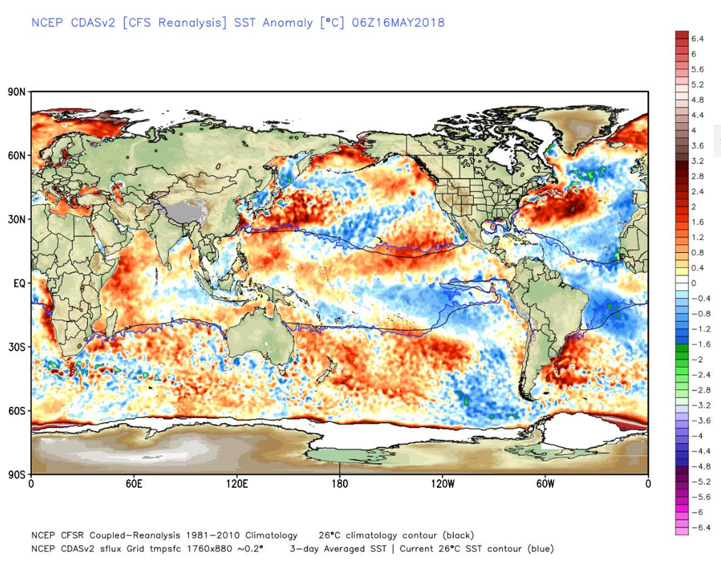
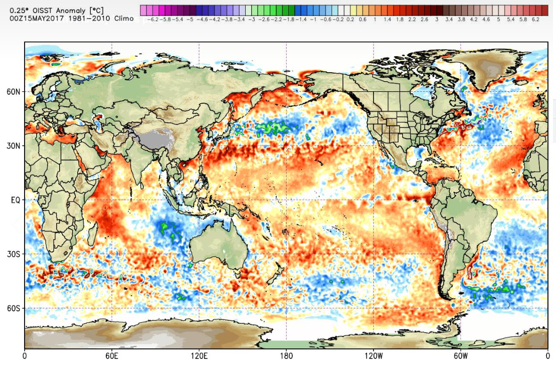
Let's see how this pans out  Good morning all, pop quiz for everyone today. I have attached the SSTs from today, and also from the same time last year. Something very significant is noticeable, something that will affect our weather in the next few years. The current picture is the first one, one year ago is the second one. Can anyone see what it is that is very significant with this? Let me know you thoughts, and if you can pick up what I have spotted here.
Daniel Marrett Loads more cool water to the Americas more warm our side. Also the Atlantic looks to be massively cooler.
Corey Blacksell Anthony, do you have an analogue period to compare your thoughts with? Anthony Violi Yes the cold AMO was when we had our wettest and coolest period in the last 100 years Rowland Beardsell When you posted this I knew it was about the Atlantic. Exciting times potentially I think! Anthony Violi Indeed,
it is now setting up for an El nino or warm Pacific for the next 24
months that we now have to have, and then its on with multiple La Ninas. |
|||
|
Wisdom has been chasing me but I've always outrun it!
|
|||
|
|||
|
Gay3
Moderator Group
Joined: 19 Feb 2007 Location: Miners Rest Status: Offline Points: 52004 |
Post Options
Thanks(0)
Quote Reply
Posted: 31 Dec 2018 at 11:24am |
||
|
The reason forecasters worldwide are having such a hard time of getting it right!
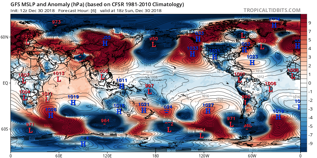
"On a side note, I have been catching up over the last day or two on goings on around the globe, I see a lot of comments about failed forecasts and teleconnections that are not working. There is a total disconnect at the moment in the climate, something I have been big one for 2 years now, with the Madden Julian Oscillation being one of these teleconnections that is not playing out as we would normally expect. At the moment, the US government is in shutdown, and all of the data I use, I cannot access until it’s resolved as NOAA is not updating any of their data. September was a great lesson for all of us, we would never see a dry month if you were given that same data 10 years ago, and we would never see the dry summer either. And there is only one culprit, in my opinion, and its water vapour, and the current status of the MJO is confirmation of that. It is currently in a realm of hyper drive so intense, that we could see something special should the cards go our way. And it is also misbehaving against the QBO as well, a lot of things that should be happening now are not, which is why both the La Nina in 2017/18, and this years attempt at El Nino, both were failures. Everywhere I look, every indicator does not do what you expect in the weeks after, even the AAO here is not doing as expected."
One only has to look at this pressure anomaly map for the globe, and notice straight away we have lower pressures at both poles, and significant too. And at the same time, how often do you think that happens? Very rare, and the only reason can be water vapour being fed into these areas, because of the extremely strong activity in the tropics, and this has to work its way South and North. So the organisation here is non existent, and that is because the oceans have warm and cold spots everywhere they shouldn’t have, and I mentioned last year, the atmosphere cant set up how it would like. In the next few days, I will update the Seasonal outlooks, I won’t be changing the outlooks in the short term, I still expect heavy summer rains to develop. But later in 2019 becomes problematic, because no matter which way this goes, these are the problems were are going to face. The only way to over come it, is a strong La Nina like 2010. That may or may not happen, we could be stuck in this rut for a bit longer, or one could develop later in 2019, the next 3 months is crucial to that. What I am looking for now is the next push from he East to firstly bring rainfall, which it will, but to also warm the Indian Ocean, with out a warm Indian, 2019 won’t be a wet year, it will remain on the dry side. Because we have an out of control tropics at the moment, that won’t matter through summer, it’s the rest of the year that is important, and we should start to see the Indian Ocean turn in the autumn, and if we get lucky, a negative IOD is on the cards. |
|||
|
Wisdom has been chasing me but I've always outrun it!
|
|||
|
|||
|
Gay3
Moderator Group
Joined: 19 Feb 2007 Location: Miners Rest Status: Offline Points: 52004 |
Post Options
Thanks(0)
Quote Reply
Posted: 30 Apr 2019 at 9:15pm |
||
|
The entire population, starting with farmers are depending on this bloke
being nearer the mark than the BOM so we can all only hope as another
generally dry year will send so many more to the wall.
My hard feed has risen by 20% but thankfully I'm only feeding one but I heard a few weeks ago a suggestion was being put to trainers to increase fees due to the surge in prices.
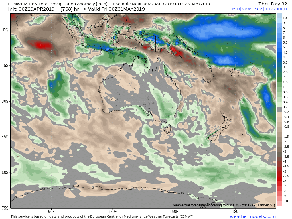
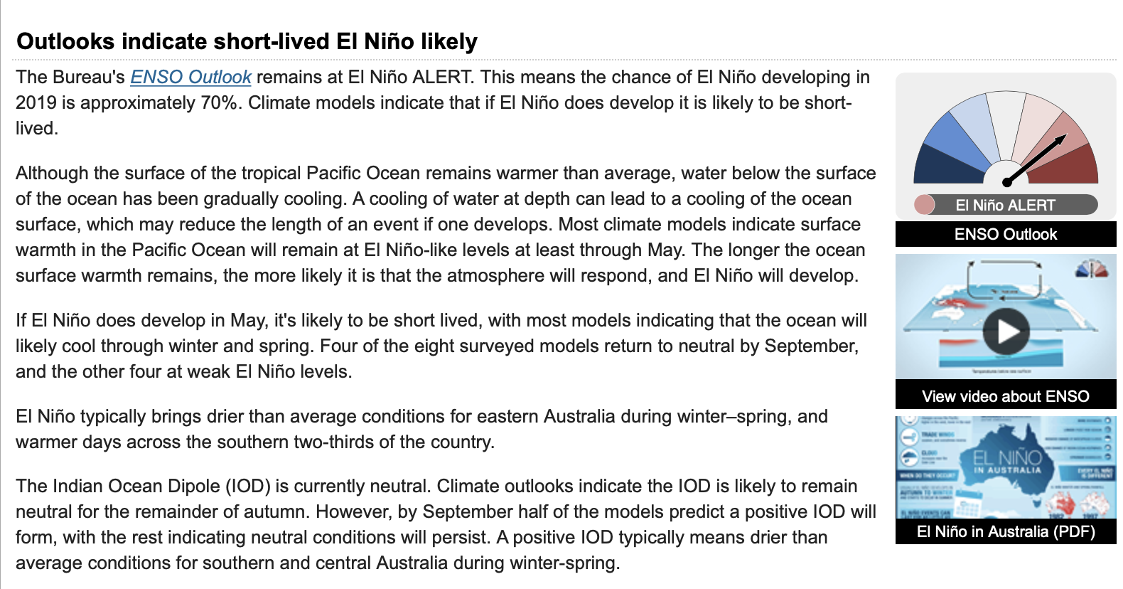
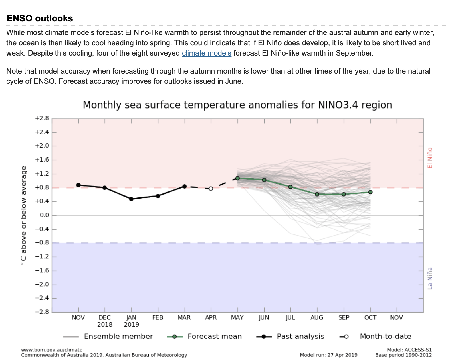
Shortly we will look at the Bom’s updated ENSO forecast, but before we do that, this forecast above is going to be another spectacular fail, because the BOMs forecasts continually reflect weak El Nino conditions that are non existent. And this will be a fail 3 days into the month, so by the end of May we should see well above average deciles for NSW, Victoria, SA and QLD, as much bigger systems will develop in the next 4 weeks.
The 46 day European forecast is above, and I have cut it down to 30 days, and it has no signal whatsoever, so either the BOMs model is woefully wrong, or they are trying to maintain this drought story line with Dave Burton, who runs the Inigo Jones page. Both of those possibilities are probably correct, the model is overstating El Nino, and they are falsely trying to say the drought will roll on, despite the best inland rain for a decade this last 3 months in much of QLD, and now much of NSW, before this forthcoming rain dumps a huge amount. So when the next update is done in Mid May, one wonders how much wetter the BOM will go, given they are running one month behind, maybe two months on their ENSO forecast tracker.
The new BOM outlook is above, and no surprises, a short lived weak El Nino event is still on the cards according to them. As you can see , they have Nino 3.4 temps int he Central Pacific at 1.0c above normal right now. And further to that, both times the pacific built up enough heat for an El Nino, the trade winds increased and destroyed the heat, and again we now see the top 300 meters of the Pcific ocean int he Nino regions losing heat fast. We are now cooler and have less heat content than anytime in the last 12 months, and continuing to fall. So the BOM are either delusional, corrupt, maybe both, I have no idea how they can believe a model when the data clearly shows something different. |
|||
|
Wisdom has been chasing me but I've always outrun it!
|
|||
|
|||
|
Gay3
Moderator Group
Joined: 19 Feb 2007 Location: Miners Rest Status: Offline Points: 52004 |
Post Options
Thanks(0)
Quote Reply
Posted: 16 Feb 2021 at 9:28am |
||
|
I know a few of us have land & therefore always trying to plan ahead, so in case it's of help, this was posted last night Personally I'll be erring on the conservative side.Gobba: AV, if all of the models you cited indicate at worst neutral to better
than neutral outlook for MJJ, what is the justification for your
outlook? Grain growers are going to be worried when you float views so contrary to all the other models you have shown and don�t put up detailed and strong analytical evidence to support your minority view. There are hundreds of millions of dollars at stake here!! I and others are always nervous at this time of year and we don�t need to be spooked. Can you provide a more detailed analytical review of the reasons for your position? Hi ?????, it is very simple, almost all of the rain NSW has received in the
last 12 months is not the result of a trough. We have virtual weather,
it is ordered by someone and they create it, you have seen me show time
and again no cold air aloft with all of this rain. It is only a matter
of time before they come out and declare you are going to have to pay
for rain, like they currently do in China and the United Arab Emirates. I am not sure if you noticed but this is war on humanity taking place right now. I am not here to spook anyone, I am here to save as many farmers as I can, because there is no future in farming in Australia, they are going to take everyones farms because you are classed as a tenant, go to the titles office if you want proof and ask them. Check the world economic Forum, they have great pleasure telling
everyone the Great Reset is coming, and you will own nothing. |
|||
|
Wisdom has been chasing me but I've always outrun it!
|
|||
|
|||
|
rusty nails
Champion
Joined: 20 Mar 2013 Location: Sydney Status: Offline Points: 11392 |
Post Options
Thanks(0)
Quote Reply
Posted: 16 Feb 2021 at 9:58am |
||
|
If China can order rain, why are they gearing up for a full blown drought?
|
|||
|
|||
|
Post Reply
|
Page <123 |
| Tweet |
| Forum Jump | Forum Permissions You cannot post new topics in this forum You cannot reply to topics in this forum You cannot delete your posts in this forum You cannot edit your posts in this forum You cannot create polls in this forum You cannot vote in polls in this forum |
Forum Software by Web Wiz Forums® version 12.05
Copyright ©2001-2022 Web Wiz Ltd.
This page was generated in 1.945 seconds.
Copyright ©2001-2022 Web Wiz Ltd.
This page was generated in 1.945 seconds.