


|
Vic Weather |
Post Reply 
|
Page 123 9> |
| Author | ||||
Second Chance 
Champion 

Joined: 02 Dec 2007 Status: Offline Points: 45805 |
 Post Options Post Options
") Thanks(1) Thanks(1)
 Quote Reply Quote Reply
 Topic: Vic Weather Topic: Vic WeatherPosted: 07 Jan 2022 at 4:38pm |
|||
|
And the Bureau has suddenly done a U-Turn, and instead of rain and a possible storm tonight and tomorrow it now says there'll be little or nothing over the next week in Central Victoria. Well f-me I could've told them that about 12-24 hours ago.
  |
||||
 |
||||
|
Gay3
Moderator Group
Joined: 19 Feb 2007 Location: Miners Rest Status: Offline Points: 52011 |
Post Options
Thanks(1)
Quote Reply
Posted: 07 Jan 2022 at 3:40pm |
|||
|
You give him too much credit SC.................wellies? They didn't occur to him 'till after the 2nd clothes change & wet weather gear? Forget it  Still little rain? Still little rain?acacia,  the hill track, it was & is the least of my concerns All that water came off the driveway si I imagine it drained off the track. the hill track, it was & is the least of my concerns All that water came off the driveway si I imagine it drained off the track.Wendy did say y/day on FB, referring to the circle tracks: Gay had 88mm and the racecourse had 104mm. The new A sand track is Mckissed, it's back to the gravel drainage in a lot of places. If we didn't have the Poly Track, we would've been stuffed for work this morning... |
||||
|
Wisdom has been chasing me but I've always outrun it!
|
||||
|
||||
|
Second Chance
Champion
Joined: 02 Dec 2007 Status: Offline Points: 45805 |
Post Options
Thanks(0)
Quote Reply
Posted: 07 Jan 2022 at 3:19pm |
|||
|
Gay's other half apparently had to don his long wellies when putting out the washing.

|
||||
|
||||
|
acacia alba
Champion

Joined: 30 Oct 2010 Location: Hunter Valley Status: Offline Points: 41524 |
Post Options
Thanks(0)
Quote Reply
Posted: 07 Jan 2022 at 3:03pm |
|||
|
Holy Dooley Gay. Has the other half got web feet yet ?? How did that uphill work gallops at the track hold up ? I hope it didnt all wsh away ??
|
||||
|
animals before people.
|
||||
|
||||
|
TJMitchell
Champion

Joined: 29 Jun 2014 Location: Melbourne Status: Offline Points: 16917 |
Post Options
Thanks(0)
Quote Reply
Posted: 07 Jan 2022 at 1:26pm |
|||
|
Humid, storm, humid, storm, humid, storm, humid. F*CK OFF!
|
||||
|
Time is a flat circle
|
||||
|
||||
|
Second Chance
Champion
Joined: 02 Dec 2007 Status: Offline Points: 45805 |
Post Options
Thanks(1)
Quote Reply
Posted: 07 Jan 2022 at 11:20am |
|||
|
Gay we've all of 1ml over the last 60 hours. Below is the Bendigo forecast but would be surprised if we get anything of note.
Humid. Partly cloudy. Medium chance of showers, becoming less likely late this afternoon and evening. The chance of a thunderstorm, with possible heavy falls.
|
||||
|
||||
|
Gay3
Moderator Group
Joined: 19 Feb 2007 Location: Miners Rest Status: Offline Points: 52011 |
Post Options
Thanks(1)
Quote Reply
Posted: 06 Jan 2022 at 4:52pm |
|||
|
We're across the road from Michelle's Dad tho' their side had 2mths worth of major drain work done after the last one in Jan 2010.
God only knows why I pay the rates when the Shire allow such dreadful engineering! 80% of the water literally gushes staright across the road Did you end up with any SC? We escaped today with only 2ml. 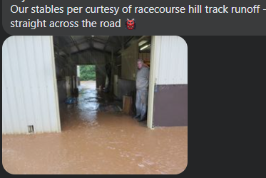   |
||||
|
Wisdom has been chasing me but I've always outrun it!
|
||||
|
||||
|
Second Chance
Champion
Joined: 02 Dec 2007 Status: Offline Points: 45805 |
Post Options
Thanks(0)
Quote Reply
Posted: 06 Jan 2022 at 12:18pm |
|||
|
We've had bugger-all rain in Bendigo thus far. There's front N-E of us but don't know that'll end in much rain here, though we could well do with 25mls or so.
|
||||
|
||||
|
Shawy38
Champion

Joined: 13 Jun 2015 Status: Offline Points: 17411 |
Post Options
Thanks(0)
Quote Reply
Posted: 06 Jan 2022 at 12:06pm |
|||
|
I saw the pictures from Michelle Payne's and also her Dad's place on her Instagram.
Looked very intense!!
|
||||
|
Winning isn't everything, it's the only thing
|
||||
|
||||
|
Gay3
Moderator Group
Joined: 19 Feb 2007 Location: Miners Rest Status: Offline Points: 52011 |
Post Options
Thanks(0)
Quote Reply
Posted: 06 Jan 2022 at 9:07am |
|||
|
I'll post photos once I have them d/loaded etc. & helped OH prepare for the next onslaught Thunderstorm charts are the main thing you need to know about today, we will again see another day of massive storms that are likely to be even bigger than yesterdays. The BOMs description talks about supercells and destructive winds, so large areas of both NSW and Victoria may see a lot of damage with these storms that develop. 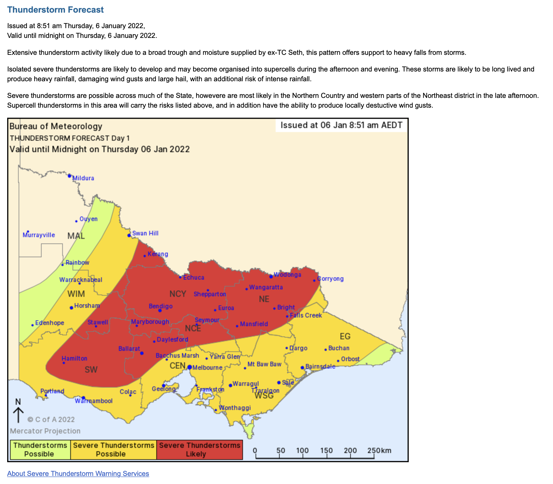 |
||||
|
Wisdom has been chasing me but I've always outrun it!
|
||||
|
||||
|
Gay3
Moderator Group
Joined: 19 Feb 2007 Location: Miners Rest Status: Offline Points: 52011 |
Post Options
Thanks(0)
Quote Reply
Posted: 05 Jan 2022 at 7:39pm |
|||
Wild weather across Victoria with flash flood warnings for areas including central Victoria, Gippsland and WimmeraPosted , updated Victorians are being told to brace for wild weather, with a warning for intense rainfall, large hailstones and damaging winds across most of the state. Key points:
The Bureau of Meteorology has issued a warning for severe thunderstorms that may produce flash flooding over the next several hours in central Victoria, Gippsland and Wimmera districts.
Locations which may be affected include Seymour, Maryborough, Kyneton, Ballarat, Geelong and Bacchus Marsh, Shepparton, Seymour, Wodonga, Wangaratta, Bright and Falls Creek. There have been reports of flooding in Ballarat, with a flash flood alert being issued for Creswick and surrounding areas as well as Miners Rest, Wendouree, Invermay and Ballarat North. A Watch and Act warning has been issued for the area, urging people to stay indoors. There have also been reports of flash floods in Melbourne's outer west.
An SES spokesperson said they had received 182 calls for assistance in the past few hours in Ballarat and its surroundings. "We have had a significant weather event happen in Ballarat," she said. "We have had a number of call-outs for floods though the area." The spokesperson said most of the requests were for floods, trees down and building damage. She urged people not to drive through floodwaters. "It is the most dangerous [thing to do]. The best idea is to pull over and stay in higher grounds." She said given the severe thunderstorm warning, the SES was expecting a lot more calls for help through the evening.
A Bureau of Meteorology spokesperson said Wilson Reservoir and the Devils Creek on Moorabool Reservoir, both towards the east of Ballarat, had received 94 millimetres and 83mm of rainfall since 9am on Wednesday morning. The SES has also urged more than 30,000 campers around the Mornington Peninsula to be cautious and prepared for strong storms. I've just tipped 88mls from a 2hr torrential storm! We were getting a bit dry but that's overkill |
||||
|
Wisdom has been chasing me but I've always outrun it!
|
||||
|
||||
|
Gay3
Moderator Group
Joined: 19 Feb 2007 Location: Miners Rest Status: Offline Points: 52011 |
Post Options
Thanks(0)
Quote Reply
Posted: 06 Mar 2019 at 11:50am |
|||
|
Rather a shock to the system
|
||||
|
Wisdom has been chasing me but I've always outrun it!
|
||||
|
||||
|
Gay3
Moderator Group
Joined: 19 Feb 2007 Location: Miners Rest Status: Offline Points: 52011 |
Post Options
Thanks(0)
Quote Reply
Posted: 14 Dec 2018 at 6:59am |
|||
|
I hope none of our members have been affected but sincere condolences to any & all who have  Kylie Stephenson
Condolences go out to everyone who lost stock in that freak storm that hit Victoria yesterday |
||||
|
Wisdom has been chasing me but I've always outrun it!
|
||||
|
||||
|
Gay3
Moderator Group
Joined: 19 Feb 2007 Location: Miners Rest Status: Offline Points: 52011 |
Post Options
Thanks(0)
Quote Reply
Posted: 13 Dec 2018 at 10:05am |
|||
|
Not designed to float? I'm quite sure many drivers don't consider this fact or even the possibility
|
||||
|
Wisdom has been chasing me but I've always outrun it!
|
||||
|
||||
|
Whale
Champion

Joined: 01 Jun 2009 Location: St Kilda Beach Status: Offline Points: 38719 |
Post Options
Thanks(0)
Quote Reply
Posted: 13 Dec 2018 at 10:01am |
|||
|
So wet I have not been able to drive to my favourite coffee spot. My car is not designed for floating
|
||||
|
||||
|
Gay3
Moderator Group
Joined: 19 Feb 2007 Location: Miners Rest Status: Offline Points: 52011 |
Post Options
Thanks(0)
Quote Reply
Posted: 13 Dec 2018 at 8:12am |
|||
|
At long, long last, some meaningful rain  & better still after our few rounds had dried enough to be bales & shedded late yesterday arvo in a do or die exercise as it had had already had 11mm since mowing & several body breaking, manual windrow turnings with our hand made wooden rakes & better still after our few rounds had dried enough to be bales & shedded late yesterday arvo in a do or die exercise as it had had already had 11mm since mowing & several body breaking, manual windrow turnings with our hand made wooden rakes  Similar to below but light steel braces. Similar to below but light steel braces.  |
||||
|
Wisdom has been chasing me but I've always outrun it!
|
||||
|
||||
|
Carioca
Champion
Joined: 13 Nov 2015 Status: Offline Points: 21830 |
Post Options
Thanks(1)
Quote Reply
Posted: 24 Mar 2018 at 10:03am |
|||
|
" Quote" I nearly killed myself yesterday,..not another fatal Gay3.
|
||||
|
||||
|
Gay3
Moderator Group
Joined: 19 Feb 2007 Location: Miners Rest Status: Offline Points: 52011 |
Post Options
Thanks(0)
Quote Reply
Posted: 24 Mar 2018 at 9:05am |
|||
|
Finally after 6wks of no rain whatsoever in B'rat (5mls in Feb for the pedantic), Hughie is sending it down & has been since 8.30
I near killed myself Thursday, weed spraying, fertilising & hand broadcating pasture seed on 2 acres, in the hope http://avweather.net would be correct in his repeated posts that this system would give more than predicted, as without his insistence, I wouldn't have risked wasting such an expense given the WZ forecast of 5-10mm Sat/Sun which frequently results in us missing out. Looks like another hour to go which may well give us around an inch of steady, soaking stuff. Too wet to check now tho' What chance Mornington to get thru'?  |
||||
|
Wisdom has been chasing me but I've always outrun it!
|
||||
|
||||
|
Gay3
Moderator Group
Joined: 19 Feb 2007 Location: Miners Rest Status: Offline Points: 52011 |
Post Options
Thanks(0)
Quote Reply
Posted: 31 Jan 2018 at 10:47am |
|||
|
I so dislike extremes

And for Tassie Snow follows summer heat as Tasmanian weather lives up to reputation for extremes12:27 EDT It is common knowledge in Tasmania to keep a coat in the car, as the weather can swing wildly from sunstroke to shivering faster than you can say "isn't this supposed to be summer?" The state's reputation for was in evidence again on Wednesday, with Hobartians reaching for the doonas during an overnight minimum of 9 degrees Celsius, just days after an overnight low of 23.9C on Monday morning broke the record for highest minimum January temperature. |
||||
|
Wisdom has been chasing me but I've always outrun it!
|
||||
|
||||
|
Shawy38
Champion
Joined: 13 Jun 2015 Status: Offline Points: 17411 |
Post Options
Thanks(0)
Quote Reply
Posted: 30 Nov 2017 at 10:22am |
|||
|
All the local farmers are out in force today trying to salvage as much crop as they can before it gets destroyed
|
||||
|
||||
|
Passing Through
Champion

Joined: 09 Jan 2013 Location: At home Status: Offline Points: 79532 |
Post Options
Thanks(0)
Quote Reply
Posted: 30 Nov 2017 at 10:17am |
|||
|
Hope the baby goats have got wellies
|
||||
|
|
||||
|
||||
|
Gay3
Moderator Group
Joined: 19 Feb 2007 Location: Miners Rest Status: Offline Points: 52011 |
Post Options
Thanks(0)
Quote Reply
Posted: 30 Nov 2017 at 10:14am |
|||
|
Max - Barwon Heads VIC says:
Is there potential for it to be as big as the Dec 2003 storm in Melbourne that was considered a ‘once in a hundred years’ storm? Seems like we average these every 7-8 years but the media (and BoM) forget the previous big event… Hi Max, that was different, that was a huge storm event that went through, and then after it was all done we had sea breeze convergence at 11 pm kick off even bigger storms in the Melbourne area. This one will be similar to Feb 1 2005, a huge cut off formed after dragging down heaps of tropical moisture and bombing the low over West Gippsland, and then the wrap around gave Melbourne and the Otways litres of rain over night with widespread gales. I still maintain we went through a Category 1 cyclone equivalent that night. This one will be similar to that. In case anyone's needing to prepare, this is the AV estimate for this event in Vic. He did cover the other States if anyone wants them. Here is the overall picture from the EC, a huge event and also good rain with the trough in QLD too So given this, here is the latest forecasts for you, I think the main change is now Central and West Gippsland are now firmly in the gun if the low bombs off the Victorian coast. Mallee : 50 – 70 mm, possible falls to 100 mm. Wimmera : 45 – 70 mm SW Vic : 35 – 60 mm Central Vic : 75 – 130 mm, higher on the ranges. Northern Vic : 50 – 100 mm North Central : 60 – 100 mm, higher on the ranges. NE Vic : 150 – 300 mm – Major flood potential West Gippsland : 100 – 200 mm – Major Flood Potential East Gippsland : 150 – 300 mm – Major Flood likely. |
||||
|
Wisdom has been chasing me but I've always outrun it!
|
||||
|
||||
|
Passing Through
Champion
Joined: 09 Jan 2013 Location: At home Status: Offline Points: 79532 |
Post Options
Thanks(1)
Quote Reply
Posted: 30 Nov 2017 at 9:58am |
|||
TOP PRIORITY FOR IMMEDIATE BROADCASTSevere Weather Warningfor HEAVY RAINFALLFor people in Central, East Gippsland, Mallee, South West, Northern Country, North Central, North East, West and South Gippsland and Wimmera Forecast Districts. Issued at 11:06 am Thursday, 30 November 2017. HEAVY RAIN AND THUNDERSTORMS FROM LATE THURSDAY A large high pressure system near New Zealand continues to direct a hot and humid northeasterly airstream over Victoria. A trough of low pressure crossing the Bight will reach western Victoria late today then become slow moving. A low pressure system will develop on the trough over northwestern Victoria on Friday then drift slowly southeastwards over the weekend. Milder, less humid southerly winds will develop behind the low, as a new high pressure system forms in the Bight. HEAVY RAIN and SCATTERED THUNDERSTORMS which may lead to FLASH FLOODING are likely to develop in the far west during TONIGHT before extending across the remaining parts of the State during FRIDAY. The heavy rain and thunderstorm activity will continue on SATURDAY. Three day totals of around 100-200mm are expected acoss most of northern and central regions of the State. Elsewhere totals are likely to be between 30 and 100mm. Over the northeast ranges totals may exceed 250mm. Locations which may be affected include Mildura, Horsham, Warrnambool, Bendigo, Shepparton, Seymour, Maryborough, Ballarat, Geelong, Melbourne, Wodonga, Wangaratta, Traralgon and Bairnsdale. The State Emergency Service advises that people should: The next Severe Weather Warning will be issued by 5:00 pm AEDT Thursday. |
||||
|
|
||||
|
||||
|
max manewer
Champion

Joined: 30 Jan 2010 Status: Offline Points: 32947 |
Post Options
Thanks(0)
Quote Reply
Posted: 30 Nov 2017 at 9:52am |
|||
|
I was talking to a bloke the other day who said the unusual rainy spring in SE Qld of 2017 reminded him of the months leading up to the 1974 Brisbane flood. I marvelled at his memory, but he might be right.
|
||||
|
||||
|
Dizzy
Premium 
Joined: 17 Sep 2013 Location: Canberra Status: Offline Points: 16863 |
Post Options
Thanks(0)
Quote Reply
Posted: 30 Nov 2017 at 9:50am |
|||
|
And we all believe the press..... Although the above is only the Melbourne forecast - other areas are expecting higher rainfall.
|
||||
|
||||
|
Passing Through
Champion
Joined: 09 Jan 2013 Location: At home Status: Offline Points: 79532 |
Post Options
Thanks(0)
Quote Reply
Posted: 30 Nov 2017 at 9:46am |
|||
|
Channel 9 are saying there could be up to 300mm over the weekend
|
||||
|
|
||||
|
||||
|
Dizzy
Premium
Joined: 17 Sep 2013 Location: Canberra Status: Offline Points: 16863 |
Post Options
Thanks(0)
Quote Reply
Posted: 30 Nov 2017 at 9:44am |
|||
|
May get a bit damp.
Friday 1 December
Melbourne areaCloudy. Very high (95%) chance of rain. The chance of a thunderstorm. Heavy falls possible. Winds northerly 20 to 30 km/h becoming light in the late afternoon. Sun protection recommended from 8:50 am to 5:10 pm, UV Index predicted to reach 12 [Extreme] Saturday 2 December
Melbourne areaCloudy. Very high (near 100%) chance of rain. The chance of a thunderstorm in the morning and afternoon. Heavy falls possible. Winds southerly 15 to 20 km/h turning southwesterly 15 to 25 km/h during the evening. Sun protection recommended from 8:50 am to 5:10 pm, UV Index predicted to reach 11 [Extreme] Sunday 3 December
|
||||
|
||||
|
Passing Through
Champion
Joined: 09 Jan 2013 Location: At home Status: Offline Points: 79532 |
Post Options
Thanks(0)
Quote Reply
Posted: 30 Nov 2017 at 9:38am |
|||
|
Bit of weather on it's way?
|
||||
|
|
||||
|
||||
|
maccamax
Champion
Joined: 18 Jun 2010 Status: Offline Points: 41473 |
Post Options
Thanks(1)
Quote Reply
Posted: 12 Aug 2017 at 9:57pm |
|||
|
Here I am in underwear only . What a climate this Brisbane has.
This global warming puts a lustre on your cluster. Affects the memory a little . >>> Which reminds me , I must turn off the bluddy heater. |
||||
|
||||
|
Rosscoe
Champion
Joined: 02 Apr 2007 Location: Brisbane Status: Offline Points: 6124 |
Post Options
Thanks(0)
Quote Reply
Posted: 12 Aug 2017 at 7:03pm |
|||
|
Meanwhile Brisbane is going to experience summer temps next week!
Tmw - 26 Mon - 26 Tues - 28 Wed - 30 Thurs - 30 Fri - 27 
|
||||
|
Current Stable - Soul Star & Adivinar + Lady Vega
|
||||
|
||||

 Topic Options
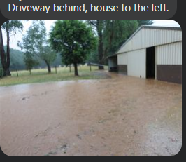
|
Post Reply
|
Page 123 9> |
| Tweet |
| Forum Jump | Forum Permissions You cannot post new topics in this forum You cannot reply to topics in this forum You cannot delete your posts in this forum You cannot edit your posts in this forum You cannot create polls in this forum You cannot vote in polls in this forum |
Copyright ©2001-2022 Web Wiz Ltd.
This page was generated in 0.094 seconds.